 |
Alan's Sharrah Pool Loop|
22 March 2025|
|
|
| START TIME |
DURATION |
DISTANCE |
PUB/ALE |
PRINTABLE MAP |
PEREGRINATION |
| 8:00am |
4.5 hours |
11.3 km/7.0 miles |
The Church House Inn / St Austell Proper Job / Dartmoor Jail Ale |
AlansSharrahPoolLoop.pdf |
29 July 2022 |
John Coombes, John Sahadat and John Wilkes (The three amigos!).
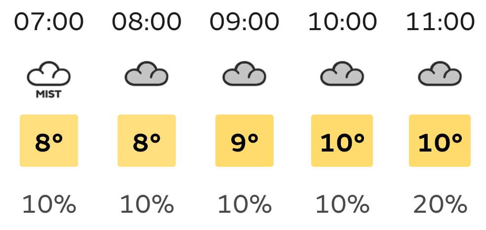
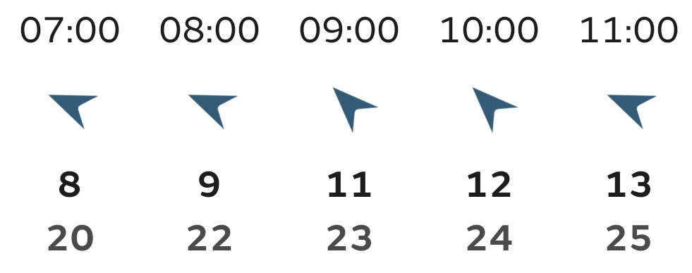
The weather for our final re-peregrination could have been better; but it stayed dry throughout so could have been much, much worse. The extensive wide angle views usually afforded from the high points of this route were curtained by a grey mist that gave a mysterious, even eerie, feeling. It did lighten as the day progressed so the reservoir and views across the valley to Dr Blackall's drive were easily visible from Bench Tor; whereas things were pretty much opaque from the top of the hill out of Michelcombe (Michelcombe Hill? Holne Moor?).
Despite the limited visibility, navigation down the hill to Venford reservoir was more successful than the original walking of this route: the secret being to stay on the north-east path from the summit until a left turn can be taken, heading north, down towards a place where a leat comes close to an established path near the head of a small, dry valley. Randomly, a solitary mechanised digger stood sentry at this way point; as if marking our true path. Then, as we approached Venford Reservoir the tall trees, and then the lake itself, spookily loomed up out of the fog, letting us know that our way down was assured.
Rather than the direct path following the boundary fence down from the tor to the river, we attempted the longer, supposedly less aggressive, path through the forest. However, the lower reaches have the path narrowing and running very near to dangerous drops into the water, and the rocks, below. Further, at higher water levels, it is doubtful whether the lowest sections of this path would be passable. The bar lady in The Church House Inn later told us that most people use this path only to climb up from The Dart to Bench Tor and it is not usually used to descend. On reflection, the direct route followed in the original peregrination is probably a better option, even if it means missing the titular Sharrah Pool: though a short diversion left at the bottom of the path would fix that.
Now that peregrinations have all been re-peregrinated, I would like to thank all of my co-walkers that have tramped along with me, especially given some of the inclement and indifferent weather we have been exposed to. Specifically, thanks to Kay, Julie, Rosie, Charlie and, not to forget, Chez and Muzz. And a particular mention to the two other Johns that have joined me on every single one of the walks; I have thoroughly enjoyed the journeys we have been on together, both literal and metaphysical; we have shared views, stories, jokes, banter, wildlife, good humour and the odd beer: indeed, all of the things that I enjoyed while walking with Alan, I'd like to think he has been looking down on us following our progress with interest. If so I'm sure he would have had a good laugh at how wet we got on some of our walks. Cheers all!
The Route
In addition, you can view the route on the Ordnance Survey site/app
Gallery
View an ARRAY of all the pictures, or click the buttons below:


![Pictures Of Our Walk]()